


November 4, 2011
Lab Report – VII
3D modeling is a familiar and useful tool in architecture, graphic design, industrial design, among other design professions. But oftentimes its development in academia is out of tune with the needs of working designers. The researchers at the University of Arkansas’ Center for Advanced Spatial Technologies or CAST are changing that divide. The group is […]
3D modeling is a familiar and useful tool in architecture, graphic design, industrial design, among other design professions. But oftentimes its development in academia is out of tune with the needs of working designers. The researchers at the University of Arkansas’ Center for Advanced Spatial Technologies or CAST are changing that divide. The group is exploring geospatial applications and theories in a wide range of disciplines to expand the knowledge of both academics as well as professionals. These include animation, archaeology, community development, environmental studies, and historical preservation.
At the UA Resource Center for Heritage Visualization they’re focusing on historic and community preservation. Rather than keeping these developments sequestered in an academic setting, their goal is to engage the public in the process, especially the young. Using 3D models and visual displays enriches the “interpretive programs of the Nation’s heritage” and engages populations in the process who might not be interested otherwise. The projects range from investigating structures from the recent past to mapping entire geographical areas from ancient Western-based history to examining single artifacts and compiling them into a virtual museum. Contemporary uses include improving the information available to city planners and the public for permits, planning, and preservation decisions.
3D computer visualizations, image via http://cast.uark.edu
The tools used from multiple datasets are combined into comprehensive visualizations. Aerial cameras, laser scanners, and geophysical devices are used to bridge “both research and public interpretation and information,” making the resulting information accessible to a wide audience.
What’s more, according to the researchers at the center, U.S. national heritage programs that use 3D models and visualization tools are not as widespread as they are in Western Europe. While this is not a development merely for the sake of competitiveness, an increase in 3D techniques can actually result in proliferating knowledge about and amongst different peoples in the U.S. In this way the quality of that knowledge (accuracy), which is measured by its scholarly rigor, and its access (efficacy) to different peoples and communities are increased.
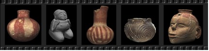
Virtual Hampson Museum, image via http://cast.uark.edu
Environmental Studies forms another major area of research at CAST. The focus here, too, is on the integration of scholarly investigations with practical applications that improve our lives. Indeed, it is not often that academic research ventures into areas of current government policy topics, but ES group does just that. Their work is in mapping land use (both human and animal) and land cover, and identifying and mapping water resources, such as wetlands and watersheds.
For example, there is the avian flight tracking of different species both in North and Latin America. The importance of tracking multiple species rather than a single species directly relates to extinction and conservation. According to the website, “11% of the world’s species are considered globally threatened with a high probability of extinction in the medium term future” (Collar et al. 1994). “Latin America alone, covering only 16% of the world’s land area, holds 30% of all threatened birds (Collar et al. 1997).”
Human agency is the single major factor in causing extinction rates 100 times faster than in the past. What’s more, because identifying single species’ potential for extinction is inefficient—many share the same general habitat–scientists have used a different approach. Mapping “hot spots” that identify threatened species’ habitats, its biodiversity, and then overlaying these findings with conservation efforts, as well as human impact, has been possible using the kinds of tools and computer techniques CAST is deploying.
Identifying and protecting both land and water resources forms another major area of analysis for this group. The issues they investigate transcend the global-warming debate as they relate to water and land. Indeed, this debate has been finally settled by one of the most notorious scientist-skeptics-turned-supporters, Richard Muller, physics professor at UC Berkeley. Rather, the researchers want to identify, ensure, and conserve the biodiversity of natural resources so that these will survive beyond the next few generations.
One project involves investigating the “gaps” in habitat preservation, for the moment using Arkansas as a model. It includes identifying land use and land cover and its change over time. Analysis of wetlands and watersheds forms the other area of research. Not only are the researchers interested in the preservation of water resources, but they are also investigating sources of contamination of drinking water, coupled with wetland analysis.
Watch as CAST researchers in the ES group work to combine the practical approaches involved in policy-making with sophisticated, computer-based research techniques to improve the quality of life for populations throughout the U.S. and the world.
Previous Lab Reports
Sherin Wing writes on social issues as well as topics in architecture, urbanism, and design. She is a frequent contributor to Archinect, Architect Magazine and other publications. She is also co-author of The Real Architect’s Handbook. She received her PhD from UCLA. Follow Sherin on Twitter at @xiaying.


